I lived in Westwood Village, Los Angeles, for over six years. It’s a charming college town amid a bustling city, distinguished from its surroundings by atypical walkability and an incredible concentration of boba shops and cafés.

Among other attractions, the village boasts not one or two, but four Starbucks within a 10-minute walk from each other–two in a multi-story Target/Ralphs’s complex, one next to the village theaters, and another one a couple blocks down, opposite the Hammer Museum. I’ve been to all four, though not on the same day–that would wreck both my mind and wallet. Still, I wanted to know if Westwood is uniquely blessed in its abundance of Starbucks and, if not, where I can find the most Starbucks in Los Angeles.
So, I decided to put my GIS skills to good use. I found a spreadsheet of every Starbucks location around the world along with street addresses. I cleaned them up and manually geocoded the locations that the program couldn’t automatically identify. Unfortunately, the best data I could find is from 2017, so more Starbucks could have opened (or closed) since then. Hopefully, the conclusions remain the same.

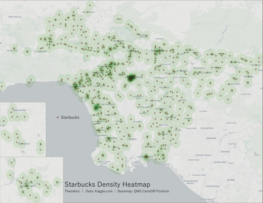
A kernel density analysis results in a simple heatmap showing the distribution of Starbucks in LA County. At first glance, we see a few obvious dark spots on the map–Pasadena, Long Beach, LAX, Santa Monica, the Wilshire Corridor leading up to Hollywood, and, of course, Downtown Los Angeles. It’s clear from the heatmap that Downtown has the highest concentration of Starbucks, but I wanted to know more. I can walk to four Starbucks in under 10 minutes from the middle of Westwood Village; just how many Starbucks can I walk to in the same amount of time in DTLA?

To answer that, we need more than a heatmap. Wikipedia says that the average human walking speed is 1.42 meters per second. Multiplied by 600, a 10-minute walk would take you 852 meters. Here, I’ve rounded it to 850 meters or about 2790 feet. To count how many Starbucks we could walk to within 10 minutes, I created an 850m wide buffer around each Starbucks. The rationale is simple: if two buffers intersect at one point, it means that, from that point, you can walk to two Starbucks. By counting the number of overlapping buffers at each intersection, I arrived at the number of Starbucks within a 10-minute walking distance for every point in Los Angeles County.
Note that the buffers are drawn as a circle with each Starbucks at the center and a radius of 850m. This does not take into account real-world factors that impact how far one can walk in 10 minutes, like road networks or pedestrian accessibility–all of which would likely slow down the hypothetical pedestrian. However, I would consider any Starbucks within a 15-minute or 20-minute walk to still be worth walking to (your mileage may vary), so an 850m straight-line distance, factoring in real-life conditions, should still work as a rough gauge of how many Starbucks are within my subjective walking distance.

I selected the four areas in the county where the concentration of Starbucks locations is highest. As the heatmap had shown, DTLA is the densest, with most of the Financial District between the 110 and 101 freeways smothered in Starbucks. There are 4 small polygons with 15 Starbucks within walking distance in this area, making them ideal destinations for those with a particular craving for iced lattes. Honestly, I’m a little surprised. In my experience, there didn’t seem to be that many Starbucks in Downtown. Whether it is because some locations are hidden away in office towers and shopping malls or because some locations have closed since this data was compiled in 2017, I can’t say.
Second place is LAX, where the multitude of airport terminals helps boost the concentration of Starbucks locations. Just off the eastern end of the north runway, one could hypothetically walk to any of the 10 Starbucks nearby. In actuality, it’s hard to see how anyone could go to even half of them, given that many are in terminals behind the TSA, to say nothing of the abysmal pedestrian infrastructure there.
Downtown Santa Monica has a more genuine concentration of Starbucks, with the densest spots having access to 8 locations within walking distance. It’s not surprising that Santa Monica and Hollywood–with 7 walkable Starbucks on Sunset Boulevard just southeast of the Chinese Theater–came in third and fourth place. Both places have relatively dense commercial cores with a lot of foot traffic.
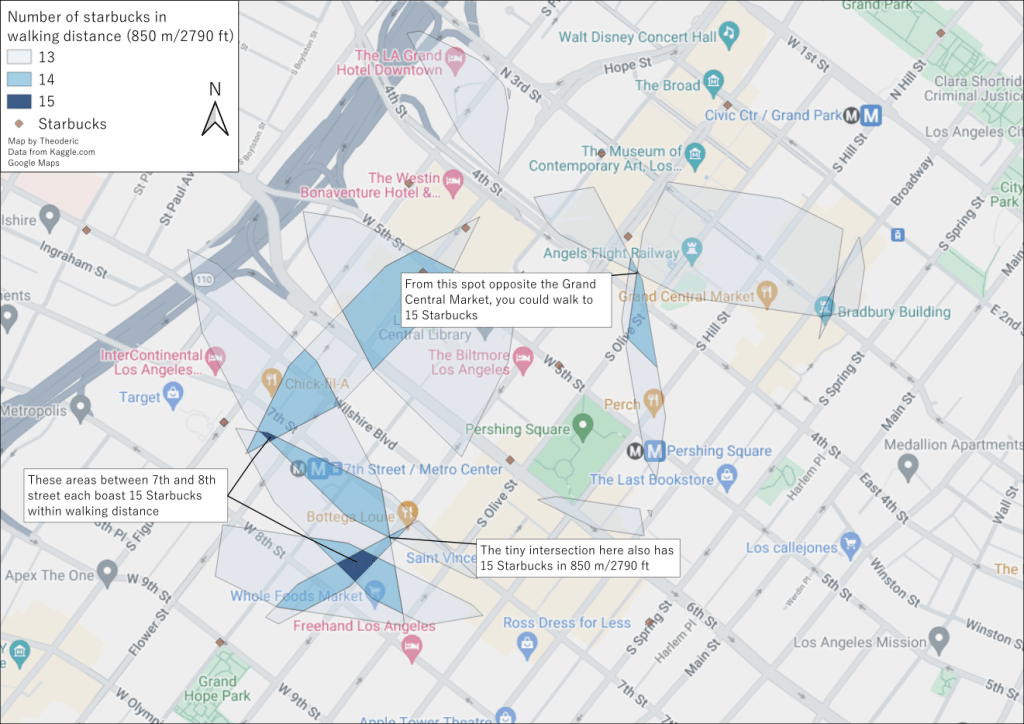
To finish it off, I wanted to focus on the four tiny spots in Downtown Los Angeles where the concentration of Starbucks–15 within walking distance–is the highest in the county. As the map above shows, apart from one tiny spot across from the Grand Central Market, the other three locations are all located in the few blocks bounded by 7th and 8th streets horizontally and Olive and Figueroa streets vertically. Given the abundance of shopping centers in and near the area (the Bloc, Figat7th) and its centrality in the Downtown area as a whole, this is within expectations. Still, I have yet to verify the situation on the ground. Someday, I’ll go and count up all the Starbucks myself–I’ll just have to try getting too hyped up on caffeine.
References:
- “Preferred Walking Speed.” Wikipedia. https://en.wikipedia.org/wiki/Preferred_walking_speed. Accessed March 6, 2024.
- Omar Sobhy. “☕Starbucks Store Location 2023:Coffee Giant Growth.” 2023. Kaggle. https://www.kaggle.com/datasets/omarsobhy14/starbucks-store-location-2023?resource=download&select=Starbucks+Store+Locations.csv. Accessed March 6, 2024.
- Google Maps. https://www.google.com/maps.
Tools used:
- QGIS 3.32.3 Lima
- MMQGIS plugin
- Density Analysis
- QuickMapServices
- Keith Jenkin’s Count Polygon Overlap Model.
Detailed methodology can be found here

Leave a comment